


By Atoyebi Nike
AccuWeather’s team of tropical experts is monitoring three areas in the Atlantic Basin for potential tropical development as the hurricane season intensifies heading into mid to late July.
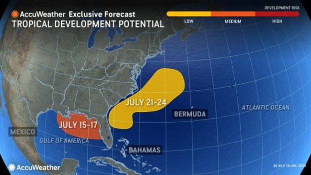
A stalling frontal boundary moving toward the southeastern U.S. coast and into the warm waters of the Gulf of Mexico could provide just enough instability for tropical activity to emerge. This setup mirrors early July conditions that led to the formation of Tropical Storm Chantal, which developed on July 4 and made landfall two days later, dumping torrential rain across parts of the Carolinas.
Communities like Chapel Hill in North Carolina received close to a month’s worth of rainfall in just 24 hours during Chantal’s impact.
Although the upcoming system is expected to encounter a weaker front and less pronounced jet stream activity than the one that formed Chantal, forecasters note that vertical wind shear is likely to be lower as well—creating a medium risk of tropical formation between July 15 and 17.
Even if a named storm doesn’t develop, the system could still bring widespread showers, thunderstorms, and the potential for localized flooding from the Carolinas down through Florida and the Gulf Coast. Beachgoers are also advised to remain cautious, as rough surf and rip currents are likely in affected areas.
Outside of this zone, conditions across the broader Atlantic Basin are expected to remain relatively quiet. Forecasters cite the ongoing presence of Saharan dust and unfavorable upper-level winds as primary inhibitors to development.
The 2025 Atlantic hurricane season has already produced three named storms—well ahead of the climatological average. Typically, the third named storm doesn’t form until early August, with the first hurricane appearing around August 11. The next name on this year’s list is Dexter, and should another storm form soon, the season would be running nearly a full month ahead of historical norms.
AccuWeather


